–/100
Route intelligence hub
Wild Atlantic Way Travel Intelligence
· AI-assisted planning intelligence
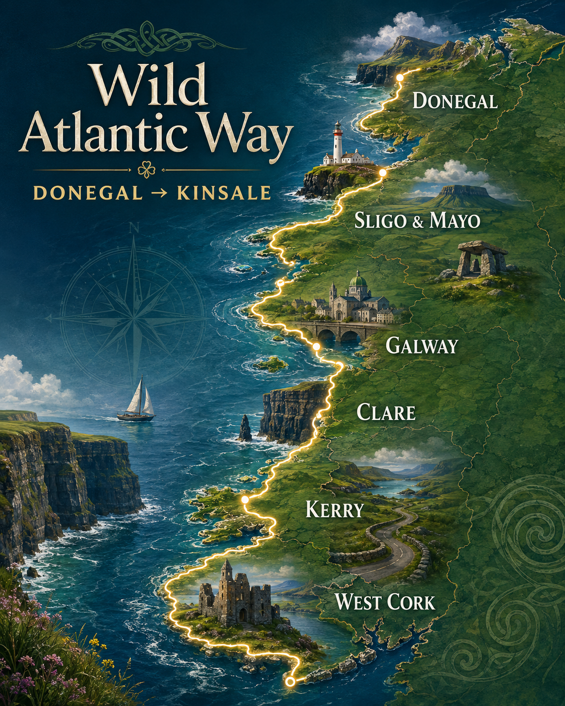
Ireland’s Wild Atlantic Way follows about 2,500 km of Atlantic coastline from the Inishowen Peninsula in County Donegal to Kinsale in County Cork. It crosses nine coastal counties and links around 180 marked Discovery Points, including 15 Signature Discovery Points. The route is strongest when planned by sections: allow roughly 14–21 days for broad coverage, or longer for a deeper end-to-end journey.
Current planning lens
Wild Atlantic Way pressure snapshot
OverallModerate → HighTwo quiet days can sit beside one overloaded transfer day; section choice matters more than the route brand.
DrivingHighNarrow roads, tractors, bends, viewpoints and unscheduled stops regularly add 30–60% to simple map estimates.
CrowdsHighly unevenCliffs of Moher, Dingle and Ring of Kerry peak sharply, while remote Donegal, Mayo and Beara can remain low-pressure.
ComfortWeather-ledWind, rain, cloud base and daylight affect cliffs, ferries, islands, beaches and long scenic drives.
Route Reality Check
How realistic is this route — for your days?
Move the slider to your trip length and pick how you'll travel. We estimate pace, pressure and where the plan breaks first. Estimates only — verify live before booking.
How you'll travel
–/100
Route sections
Where this route breaks first
Distances, times and scores are estimates, not live timetables.
Travel Essentials
What to pack for Wild Atlantic Way
Crowd-tested essentials for the Wild Atlantic Way, drawn from travellers who recently drove the route. The Atlantic coast brings four seasons in a day — pack for weather, not the calendar.
Before you go
- UK ETA for Northern Ireland If your route crosses into Derry, the Causeway Coast or anywhere in Northern Ireland, non-Irish/non-UK visitors need a UK Electronic Travel Authorisation. Apply before you fly — it is separate from any EU entry rules. Tell your car-hire company you are crossing the border.
- Two payment cards (Visa/Mastercard) Contactless and Apple/Google Pay are widely accepted. Carry a backup card and some cash for small rural pubs, vendors and tips.
- Type G plug adapter (multi-port) Ireland uses the three-pin Type G plug. B&Bs often have few sockets, so a single adapter with multiple USB ports saves charging headaches.
Weather & layers
- Waterproof jacket — not water-resistant The single most repeated piece of advice. A hooded, genuinely waterproof shell with a hood. Re-proof an older coat before you travel. Skip the umbrella — Atlantic wind destroys them.
- Layers, not seasons Expect cold, wind, mist, rain and sun in one day even in July. A fleece or light puffy plus interchangeable tops beats heavy single garments.
- Waterproof walking shoes You will live in them. Waterproof trail shoes or light hiking boots handle headland paths, wet grass and uneven ground. Bring a second dry pair.
- Hat and hair tie Coastal wind makes styled hair pointless. A warm hat or buff for exposed headlands, and something to tie hair back.
Pack light
- Quick-dry clothes, minimal jeans Frequent base changes mean washing as you go. Merino or technical fabrics dry overnight and resist odour; denim takes days and B&B washer-dryers struggle with it.
- Carry-on plus a daypack You may change accommodation most nights. A small daypack holds your rain shell, water bottle and souvenirs while you explore; a carry-on plus laundry beats a large case on narrow stairs.
- Laundry sheets or detergent Plan to rinse clothes in the sink or use laundromats. Travel detergent sheets pack flat.
Comfort extras
- Eye mask July daylight stretches very late and starts early. An eye mask helps in B&Bs without blackout blinds.
- Power bank Long days of navigation, photos and offline maps drain phones. A power bank — and a charging cable left in the car — keeps you covered.
- Motion-sickness tablets Coastal and peninsula roads are winding. Non-drowsy tablets are worth packing even if you don't usually need them, especially on coach tours.
- Washcloth Many B&Bs don't provide them. A quick-dry travel cloth covers the gap.
- Reusable water bottle and travel mug Refill on the go, cut waste, and grab coffee for long scenic drives.
Crowd-sourced guidance for general planning. Verify entry rules, weather and opening hours with official sources before you travel.
Route essentials
Practical basics for Wild Atlantic Way
About 2,500 km
From Inishowen in Donegal to Kinsale in Cork along Ireland’s Atlantic coast.
Around 180 marked points
The current Discover Ireland route highlights about 180 Discovery Points, including 15 Signature Discovery Points.
Nine coastal counties
Donegal, Leitrim, Sligo, Mayo, Galway, Clare, Limerick, Kerry and Cork.
Roughly 32 hours
That excludes sightseeing, weather, ferries, meals, local-road delays and accommodation access.
14–21 days
Three to four weeks gives a much deeper end-to-end journey; one week should cover selected sections only.
Section-based road trip
Use two- or three-night bases instead of changing accommodation every night.
Shannon, Knock, Cork, Dublin
Choose the airport after fixing the first and final route sections, not before.
May–June / September
Long daylight and lower peak pressure, but always verify seasonal ferries, B&Bs and local services.
Why smarter planning matters
Wild Atlantic Way is spectacular — and operationally demanding
The route is not one continuous attraction but a chain of headlands, peninsulas, islands, small towns, ferries and weather-exposed roads. A simple map hides the real load created by left-hand driving, single-track sections, tractors, photo stops, weak mobile signal, seasonal services, parking pressure and repeated accommodation changes. Strong planning means choosing a limited number of route families, using two- or three-night bases, downloading offline maps, protecting ferry and weather buffers, and leaving time to spend with local businesses rather than treating every village as a fuel stop.
Route basics
Stable travel intelligence
There is no single best gateway. Shannon fits Clare, Galway and parts of Kerry; Ireland West Airport Knock fits Mayo, Sligo and south Donegal; Cork fits West Cork and the southern finish. Dublin offers the widest flight choice but can add a long cross-country first or final day. Choose flights only after fixing the route section and final-night logic.
A car remains the strongest option for an end-to-end journey, but public transport is not absent. TFI Local Link, Bus Éireann, rail gateways and private operators can support base-led sections around Sligo, Westport, Galway, Killarney, Cork and selected coastal towns. Treat this as a 2/5 route-wide public-transport fit: workable in fragments, not a continuous car-free coastal line.
Plan by six route families: Northern Headlands, Surf Coast, Bay Coast, Cliff Coast, Southern Peninsulas and Haven Coast. One peninsula or one major coastal cluster per day is usually enough. Two- or three-night bases reduce packing, parking, check-in friction and driver fatigue.
Atlantic conditions can change within hours. Low cloud can erase cliff views, strong wind can suspend exposed walks or boat trips, and winter daylight sharply reduces useful driving time. Some B&Bs, ferries and visitor services reduce schedules outside the main season. Midges can also affect calm, damp areas in warmer months, especially around bog and lake landscapes.
Ireland is generally low-risk for visitors, but the Wild Atlantic Way adds road, cliff, weather, ferry and remote-service risks that are more important than broad security pressure.
Ireland is outside the Schengen Area. Common Travel Area free-movement rights primarily apply to Irish and British citizens; other travellers should verify Irish and UK document or visa rules separately before crossing into Northern Ireland or travelling onward to Great Britain. English is widely used. Irish is especially visible in Gaeltacht areas in Donegal, Galway, Kerry and Cork; road signs may be bilingual or Irish-only in some districts.
Drive on the left. Many scenic sections use narrow or single-track roads with bends, tractors, cyclists, livestock and limited passing places. Connor Pass, Gap of Dunloe, Healy Pass and approaches to places such as Slieve League need vehicle-size and weather awareness. If arriving through Dublin, confirm how the rental company handles the barrier-free M50 toll; when the driver is responsible, payment is due by 20:00 the next day.
Small coastal towns can sell out during summer weekends, festivals and good-weather windows. Book anchor nights first, especially around Dingle, Doolin, Galway, Westport and popular Kerry bases, while preserving cancellation flexibility. Outside the main season, verify B&B, restaurant, ferry and attraction opening rather than assuming full service.
Aran Islands services, the Shannon crossing, Valentia Island ferry, Dursey Island cable car and other seasonal boats create fixed-time anchors and weather dependence. Timetables and operating conditions vary. Do not stack a ferry, a long scenic drive and a fixed dinner or non-refundable check-in in one fragile chain.
Fuel stations and mobile coverage become less predictable in remote Donegal, Mayo, Connemara, Beara and West Cork. Refuel before long peninsulas, download offline maps and save accommodation details before leaving a main town. Use marked paths and authorised parking; never stop on blind bends, block farm entrances or treat every map pin as a safe viewpoint.
Official route anchors
15 Signature Discovery Points
Use these major landmarks to understand the route — not as a compulsory checklist. The best journey combines a few signature stops with smaller Discovery Points, local towns and longer regional bases. Where coordinates are available, tap a maps link to launch navigation — rural coordinates are often more reliable than postal addresses, and mobile signal can be patchy on headlands, so download offline maps before you set off.
-
Malin Head County Donegal Ireland’s northernmost mainland point, with exposed headland roads, ocean weather and limited shelter. Google Maps Apple Maps Waze
-
Fanad Head County Donegal A lighthouse peninsula with dramatic Atlantic views; allow time for the long approach and local road conditions. Google Maps Apple Maps Waze
-
Sliabh Liag / Slieve League County Donegal High sea cliffs with steep walking options; check shuttle, parking, wind and visibility before arrival. Google Maps Apple Maps Waze
-
Mullaghmore Head County Sligo A compact coastal loop known for surf, Classiebawn views and strong wind or swell exposure. Google Maps Apple Maps Waze
-
Downpatrick Head County Mayo A cliff-top viewpoint over the Dún Briste sea stack; stay well back from unprotected edges in poor weather. Google Maps Apple Maps Waze
-
Keem Bay County Mayo A striking Achill beach reached by a steep scenic road; summer parking fills quickly and mobile signal can vary. Google Maps Apple Maps Waze
-
Killary Harbour County Galway A mountain-framed Atlantic inlet best treated as a regional base or slow stop rather than a quick photo pull-in. Google Maps Apple Maps Waze
-
Derrigimlagh County Galway Blanket bog, Marconi radio history and Alcock–Brown aviation heritage on an exposed walking and cycling route. Google Maps Apple Maps Waze
-
Cliffs of Moher County Clare Ireland’s busiest cliff attraction; book and arrive early, allow for wind, and use only official paths. Google Maps Apple Maps Waze
-
Loop Head County Clare A quieter lighthouse peninsula between the Atlantic and Shannon Estuary, with long access roads and exposed conditions. Google Maps Apple Maps Waze
-
Radharc na mBlascaodaí / Blaskets View County Kerry A Dingle Peninsula viewpoint toward the Blasket Islands, where visibility and road comfort depend heavily on weather. Google Maps Apple Maps Waze
-
Skellig’s View — Bray Head, Valentia Island County Kerry A Valentia Island viewpoint toward the Skelligs; allow for island access, walking time and rapidly changing visibility. Google Maps Apple Maps Waze
-
Dursey Island County Cork Ireland’s cable-car island crossing; operating times, capacity and weather can define the whole day. Google Maps Apple Maps Waze
-
Mizen Head County Cork A dramatic southwestern headland with bridge and cliff walks; check opening hours, wind and late-day travel time. Google Maps Apple Maps Waze
-
Old Head of Kinsale County Cork The southern route anchor, with coastal viewpoints and signal-tower history; some headland land remains privately controlled. Google Maps Apple Maps Waze
Lucky Earth heuristic
Slow Travel Fit
70/100
Wild Atlantic Way rewards slower section-based travel, stable bases, local businesses and fewer transfers. The score is reduced by route-wide car dependency, exposed weather, thin coastal public transport and the operational cost of ferries, peninsulas and remote services.
What breaks first
The Wild Atlantic Way friction checklist
The 2,500 km line becomes shallow and exhausting when every Signature Point is compulsory. A one-week trip should select route families, not attempt the full coast.
On peninsulas and local roads, tractors, bends, cyclists, livestock, viewpoints and weather can add 30–60% to a simple navigation estimate.
Overseas drivers need recovery time after arrival. Narrow sections, passing places and exposed passes demand slower speeds and full attention.
Remote headlands may have limited fuel, weak reception and few late-opening services. Refuel early and keep offline maps plus saved booking details.
Island boats, Shannon crossings and seasonal services have fixed cut-offs and weather exposure. Missing one departure can collapse the rest of the day.
Cliffs of Moher, Dingle, Galway and Ring of Kerry viewpoints can change from manageable to overloaded within one coach-arrival window.
Trip Check focus
Before booking Wild Atlantic Way dates
How many sections, bases and real driving hours fit the available nights without turning the journey into a transfer chain?
Are you comfortable with left-side driving, narrow roads, passing places, manual transmission and weather-exposed routes?
Are ferries, island boats, cable cars, tours and dinner reservations stacked after slow-road driving?
Which cliffs, ferries, beaches or viewpoints fail first in wind, rain, low cloud or reduced daylight — and what is the fallback?
Does the route include remote sections where fuel, mobile coverage, food or late check-in options are limited?
Is the final night close enough to the departure airport without relying on one long cross-country drive?
Beyond the obvious
Route-depth ideas
Northern Headlands — Donegal
Inishowen, Fanad, Slieve League and Gaeltacht communities deliver the wildest and least compressed section, but distances are longer than they look.
Use Letterkenny, Donegal Town or a coastal village as a multi-night base. Do not combine Inishowen and Slieve League in one quick day.Surf Coast — Sligo and Mayo
Surf beaches, Benbulben, Céide Fields, Downpatrick Head and smaller coastal towns combine archaeology, landscape and strong local identity.
Base in Sligo, Ballina or Westport and make short loops. Keep Achill and north Mayo for separate days.Bay Coast — Galway and Connemara
Galway, Connemara, Killary, islands and bog roads create the most varied section, but ferries, parking and weather dependencies are substantial.
Choose either Connemara or the Aran Islands on a short stay. Use Galway for city access and Clifden or another regional base for deeper travel.Cliff Coast — Clare and the Burren
The Cliffs of Moher and Burren limestone landscape are iconic, while Doolin, Ballyvaughan and Loop Head offer a wider cultural and ecological context.
Visit the main cliffs early or late, then give time to a Burren walk, village or Loop Head rather than another coach-heavy stop.Southern Peninsulas — Kerry
Dingle, Iveragh and Beara are high-value slow-road landscapes where scenic stops, single-track roads and weather repeatedly defeat tight schedules.
Choose one peninsula per day and avoid booking an inflexible dinner immediately after a full scenic loop.Haven Coast — West Cork
Kinsale, Baltimore, Mizen, Sheep’s Head and coastal food communities create a softer southern finish with strong village-to-village value.
Use one West Cork base for several nights and avoid racing from Mizen or Baltimore directly to Dublin on departure day.One-region weekend escapes
The Wild Atlantic Way works well as repeat regional trips: Donegal, Mayo, Clare, Dingle, Beara or West Cork each justify a separate weekend or short break.
Start from the nearest practical rail, airport or motorway gateway and build a compact loop instead of chasing route completion.Signature Point plus local depth
The 15 Signature Discovery Points are useful anchors, but the route’s value also sits in 180 Discovery Points, smaller towns and unhurried coastal stops.
Pair one famous stop with one village, walk, market or local food stop; avoid building days from three headline viewpoints.Travel more locally
Support local communities while reducing friction
- Use two- or three-night bases and spend in local cafés, pubs, shops, guides and family-run accommodation instead of treating villages as fuel stops.
- Travel one hour earlier or later than coach peaks at headline viewpoints, then use the saved time for a smaller nearby town, beach or walk.
- Choose local ferries, walking guides, surf schools and food producers with clear safety and environmental practices.
- Respect farm access, private land, dunes, nesting areas and cliff paths; use marked parking rather than creating roadside pressure.
- Build at least one lower-mileage day into every three- or four-day section so weather changes do not destroy the whole plan.
- Use refillable bottles and reusable food containers, but never assume rural refill points or late-opening shops will be available.
- Stay longer in Donegal, Mayo, Beara or West Cork when possible; lower-pressure spending matters more than collecting another famous viewpoint.
Watch before you go
Route video briefing
▶
Travel videoLooking for a useful Wild Atlantic Way briefing video…
This uses the same Lucky Earth YouTube travel endpoint as the map snapshots.
Route sections
Route sections and extensions
Practical side trips with realistic transport details.
3–4 nights · northern section
Donegal and Northern Headlands
🚉 How to get there
Start from Derry/Letterkenny, Ireland West Airport Knock or drive north from Dublin. Use one or two bases rather than tracing every peninsula.
Inishowen, Fanad, Slieve League, beaches, Gaeltacht culture and low-density coastal travel.
⚠️ Long distances, thin evening transport and Atlantic exposure make rushed loops fragile.
3 nights · surf and heritage
Sligo, north Mayo and Achill
🚉 How to get there
Use Sligo, Ballina or Westport as anchors. Rail reaches Sligo/Westport, but a car or local tour is usually needed for the coastal layer.
Surf beaches, Benbulben, Céide Fields, Downpatrick Head, Westport and Achill.
⚠️ Do not combine Achill, Céide Fields and Connemara in one day.
3–4 nights · bay section
Galway and Connemara
🚉 How to get there
Reach Galway by rail/coach, then use Galway, Clifden or another Connemara base depending on whether the focus is city, islands or road loops.
Food, trad music, Killary, islands, bog roads and Atlantic villages.
⚠️ Island ferries, narrow roads and summer accommodation pressure need buffer.
2–3 nights · cliffs and limestone
Clare, Burren and Loop Head
🚉 How to get there
Use Ennis, Doolin, Lahinch or Ballyvaughan as bases. Shannon Airport is the strongest international gateway for this section.
Cliffs, limestone landscape, walking, music, villages and coastal loops.
⚠️ Cliffs of Moher weather, parking and coach waves can dominate a badly timed day.
4–6 nights · peninsula route
Kerry: Dingle, Iveragh or Beara
🚉 How to get there
Use Killarney, Dingle, Kenmare or a peninsula village as a base. Choose one major peninsula loop at a time.
Mountain-and-sea roads, beaches, islands, food and slower coastal culture.
⚠️ Single-track roads and scenic stops make map times unreliable; avoid stacking two peninsulas.
3–4 nights · southern finish
West Cork to Kinsale
🚉 How to get there
Use Cork Airport or Cork city as the gateway, then base around Kinsale, Clonakilty, Skibbereen, Baltimore or Bantry depending on the loop.
Food, harbour towns, Mizen, Sheep’s Head, islands and a calmer southern conclusion.
⚠️ Public transport between small coastal stops is limited; final-day airport or Dublin drives need a realistic buffer.
Compare & plan
Continue planning across Ireland
Dublin, Ireland
Plan a smarter, safer and more local trip to Dublin — with practical pressure around airport buses, rain and wind, Dublin Pride, Calvin Harris outdoor shows, Malahide Castle concerts, Temple Bar prices, trad music timing, Dublin Bay routes and lower-impact city choices.
Galway 30-day snapshot
Check current crowd, weather, event and transport pressure before using Galway as a Bay Coast base.
Donegal 30-day snapshot
Check current conditions before building a Northern Headlands route around Donegal.
Planning scope
How to use this route intelligence
Treat this page as route-level planning intelligence rather than an official road, weather, immigration or safety source. Current Discover Ireland material describes about 2,500 km of coastline, around 180 marked Discovery Points and 15 Signature Discovery Points. Use the page to compare route families and identify operational pressure, then verify ferries, cable cars, road notices, M50 payment responsibility, weather warnings, attraction access and border requirements through official sources.
Local partner slots
Local services for Wild Atlantic Way travellers
Featured cafés, guides, stays and useful services connected to this City Hub.

Local cafés, guides, stays and useful route services will appear here as the partner network grows.
Seen by travellers
Community photos
Traveller and local photos appear here after approval. Scroll sideways to view approved photos and open photo slots.
Scroll sideways to see more photo slots.
Traveller-reported insight
Community notes
Choose two or three Wild Atlantic Way sections instead of trying to drive the full coast in a short holiday.
Traveller-reported · 2026-06-15Map estimates regularly understate coastal driving time because of narrow roads, weather and scenic stops.
Traveller-reported · 2026-06-15Use two- or three-night regional bases to reduce luggage moves and support local communities.
Traveller-reported · 2026-06-15FAQ
Wild Atlantic Way travel questions
How many days do I need, and can I drive the full Wild Atlantic Way in one week?
The route is about 2,500 km before detours, islands and local loops, so one week is best treated as a regional road trip rather than an end-to-end challenge. With 7 nights, choose one large section or two neighbouring route families. With 10–14 nights, three or four regions can work if you use multi-night bases. Allow roughly 14–21 days for broad end-to-end coverage, and three to four weeks for a deeper journey with weather buffers, islands and slower local stops. Count real driving hours, check-ins and sightseeing — not only the distance shown by navigation apps.
Do I need a car, and what can I realistically do without one?
A car gives the most flexibility for an end-to-end journey, remote headlands and peninsulas. A car-free trip is still realistic when built around strong gateways such as Sligo, Westport, Galway, Killarney and Cork. From those bases, combine rail or intercity coach with TFI Local Link, Bus Éireann, private buses, ferries, organised day tours, taxis, walking or cycling. The key limitation is continuity: public transport reaches many useful places, but it does not operate as one seamless coastal service. Choose fewer bases, check the final return service first and avoid assuming that every scenic stop has a same-day connection.
What should overseas drivers know before renting a car?
Ireland drives on the left, and many Atlantic roads are narrow, winding or single-track, with passing places, tractors, cyclists, livestock and sudden viewpoints. Keep the arrival day light, especially after a long flight. Confirm manual versus automatic transmission, insurance excess, additional-driver charges, one-way drop fees and permission to cross into Northern Ireland. Ask the rental company who pays the barrier-free M50 toll; when the driver is responsible, it must be paid by 20:00 the following day. Refuel before remote peninsulas, save accommodation details and download offline maps before mobile coverage becomes weak.
Which section is best for a first Wild Atlantic Way trip?
Choose by travel style rather than by the idea of completing the route. Galway–Clare–Kerry gives the most recognisable first trip: Galway, Connemara, the Burren, Cliffs of Moher and major peninsulas, but it also carries the strongest crowd and accommodation pressure. Donegal and Mayo feel wilder and quieter, with longer drives and thinner evening services. Sligo–Mayo suits surf, archaeology and walking. West Cork suits food, harbour towns and gentler multi-night bases. Families often benefit from Clare or West Cork; repeat visitors and slow travellers usually gain more from Donegal, Mayo, Beara or smaller regional loops.
Which airport should I use, and where should I start and finish?
Choose the route section first and the airport second. Shannon is usually the strongest gateway for Clare, Galway and parts of Kerry. Ireland West Airport Knock fits Mayo, Sligo and south Donegal. Cork fits West Cork, Beara and the southern finish. Dublin offers the widest flight choice but can create a long cross-country first or final day. Belfast or Derry may suit northern Donegal, but cross-border entry, insurance and rental conditions must be checked. One-way car rental can reduce backtracking, but compare the full fee. Keep the final night within a comfortable transfer of the departure airport.
When is the best time to travel, and what changes outside summer?
May, June and September often provide the best balance of useful daylight, open services and lower peak pressure. July and August offer the broadest operating schedules but also the highest accommodation prices, coach waves and parking pressure. April and October can work well for flexible travellers, although rain, wind, shorter daylight and reduced services matter more. In winter, the coast can be dramatic but useful driving time is limited and some B&Bs, restaurants, visitor attractions, island boats and seasonal services reduce hours or close. Verify every ferry, cable car, attraction and rural check-in rather than relying on last season’s timetable.
How far should I drive each day, and how should I plan ferries or islands?
Plan by steering time and route complexity, not kilometres alone. On peninsulas and local roads, a day that looks short can fill up with bends, tractors, photo stops, parking, short walks and weather changes. One peninsula, island or major coastal cluster is usually enough for a full day. Treat ferries, island boats and cable cars as fixed-time anchors: follow the operator’s check-in requirement, allow parking and boarding time, and keep a weather fallback. Avoid linking a long scenic drive, the last departure of the day and a non-refundable dinner or accommodation booking in one fragile chain.
How should I budget for a Wild Atlantic Way trip?
The headline car or room price is not the full trip cost. Budget separately for accommodation, the complete rental package, fuel, tolls, parking, ferries or island boats, food and paid attractions. Automatic cars, lower insurance excess, an additional driver and one-way rental can materially change the car total. Coastal accommodation is the biggest seasonal variable, especially on summer weekends and around Dingle, Doolin, Galway, Westport and popular Kerry bases. Multi-night stays, self-catering, earlier booking and shoulder-season travel usually control costs better than changing hotels every night. Keep a contingency for weather-led changes or missed connections.
Is the route suitable for families and travellers with limited mobility?
Yes, but comfort depends on section choice and daily pacing. Families usually do better with two- or three-night bases, shorter drives, beaches, aquariums, farms, easy walks and one major attraction per day. Accessibility varies sharply: some viewpoints have good parking and surfaced access, while cliff paths, bog tracks, beaches, historic boats and small ferries may involve steep, uneven or exposed ground. Check toilets, parking distance, gradients, wheelchair or pram access and boarding arrangements directly with each attraction or operator. Build an indoor or low-effort alternative for days when wind and rain make exposed stops unsuitable.
Can I travel the route in a campervan or motorhome?
Yes, but vehicle size changes the route. Large motorhomes are less comfortable on narrow peninsulas, mountain passes, village streets and small viewpoint car parks. Use registered campsites or clearly authorised overnight areas, pre-book popular regions in summer and check height, length and access restrictions before committing to a road or car park. Do not block passing places, farm entrances, homes or emergency access, and never assume that a scenic lay-by permits overnight stays. Plan legal waste disposal, water, electricity and toilet servicing; responsible campervan travel depends on local facilities, not informal roadside camping.
Can I combine the Wild Atlantic Way with Northern Ireland?
Yes. Northern Donegal connects naturally with Derry and the Causeway Coast, but the Republic of Ireland and Northern Ireland are different immigration and legal jurisdictions. Travellers who are not Irish or British citizens should verify current Irish and UK visa or Electronic Travel Authorisation requirements for their nationality and itinerary. Confirm that the rental company permits cross-border travel and that insurance, breakdown cover and any one-way arrangements remain valid. Also check mobile roaming and currency expectations: Northern Ireland uses pounds sterling, while the Republic uses euro.
How can I travel more slowly and support local communities?
Use fewer bases and stay two or three nights instead of treating every town as a short stop. Buy food locally, choose family-run accommodation, qualified local guides, ferries, surf schools, crafts and community businesses, and visit headline viewpoints outside coach peaks. Pair one famous stop with a village, market, short walk or local meal. Use marked parking, respect private land, farm access, dunes, nesting areas and cliff-path closures, and carry reusable water and food containers without assuming rural refill points are always available. A lower-mileage day every few days makes the trip safer and keeps more spending in one community.
What should I pack for the Wild Atlantic Way in summer?
Pack for weather, not the season — the Atlantic coast can deliver cold, wind, mist, rain and sun in a single July day. The essentials travellers repeat most: a genuinely waterproof hooded jacket (not water-resistant), interchangeable layers including a fleece or light puffy, waterproof walking shoes with a dry backup pair, and a Type G multi-port plug adapter. Skip the umbrella, since Atlantic wind destroys them, and limit jeans in favour of quick-dry fabrics because you will change bases often and wash as you go. Add an eye mask for long summer daylight, a power bank, and motion-sickness tablets for winding coastal roads.
Do I need a UK ETA or visa for the Northern Ireland part of the route?
If your Wild Atlantic Way trip crosses into Northern Ireland — for example to reach Derry, the Causeway Coast or the Glens of Antrim — most non-Irish and non-UK visitors now need a UK Electronic Travel Authorisation (ETA). It is separate from any EU/Ireland entry rules and must be arranged before you travel. Apply online in advance, keep the confirmation accessible, and tell your car-hire company you intend to cross the border, as some hire agreements and insurance require notice for Northern Ireland travel. Always confirm current requirements with official UK and Irish government sources before booking.
Is the full Wild Atlantic Way too much to drive in one trip?
For most one- or two-week trips, yes — and this is the most common regret travellers report. The route is roughly 2,500 km before islands, peninsulas and local loops, and navigation apps consistently understate real driving time: tractors, bends, single-track roads, livestock, viewpoints and weather can add 30–60% to an estimate. Galway to the Causeway Coast, for instance, can take a full day rather than the few hours a map suggests. Rather than collecting the whole coast, choose one or two neighbouring route families and use multi-night bases. Our Route Reality Check below lets you set your trip length and transport mode to see where a plan breaks first.